Mariner GPS Dashboard 3.8 rolls out on the Play Store this week with an exciting new feature for sailors. You can now connect to your boat’s NMEA 0183 network to stream GPS location and wind data into the apps. This article is your complete guide on getting NMEA set up in the latest version of Mariner.
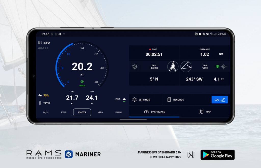
Mariner GPS Dashboard is a marine GPS dashboard for sailors that calculates your speed in real time, assists you in estimating travel time en route, and records your logbook automatically.
The app is part of the RAMS (Road Air Marine Speedometers) range of mobile and wearable GPS Dashboards tailored specifically to different modes of transport; Velocity for land vehicles and Mariner for marine vessels.
What is NMEA?
NMEA (National Marine Electronics Association) is an organisation that develops the most widely-used standards of communication between devices on sailing vessels. A boat’s NMEA network facilitates the exchange of data between the boat’s electronics, such as GPS receivers, anemometers (wind sensors), depth sensors, radar and sonar devices. Display devices can connect to the network NMEA to show data from multiple sources.
The hardware component of the NMEA network consists of a ‘backbone’, which is essentially a cable with all the boat’s devices attached to it. Devices on the network can either be be ‘talkers’ that provide their data to other devices (such as GPS receivers, anemometers) or ‘listeners’ that receive and display the information sent by the talkers (such as cockpit displays, smartphones). Real-time data from each talker is combined into a single data signal called a ‘sentence’ which all NMEA-capable devices can understand.
NMEA 0183 vs. NMEA 2000
There are two commonly used NMEA protocols; NMEA 0183 (since March 1983), and the more recent NMEA 2000 (Since 2001). The latter improves on both the hardware and software components of the 0183 standard by simplifying the backbone connectivity between devices and by sending data faster and more efficiently throughout the network.
NMEA 0183 is still the most widely used standard, as many workboats built before the advent of NMEA 2000 will have their 0183 devices well integrated. The newer NMEA 2000 standard is supported by more recent boats and devices, and is more commonly used by recreational boaters.
An NMEA 2000 network can support 0183 devices simply by adding a ‘conversion gateway’ device to the network. Many NMEA-capable devices support both 0183 and 2000 protocols, while others support only one of the protocols.
Getting started
The NMEA 0183 protocol is supported as of version 3.8
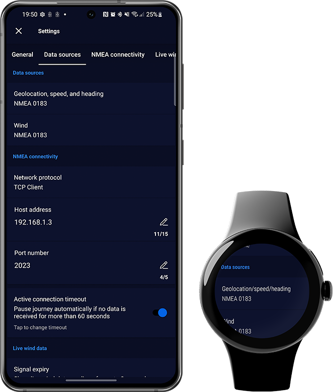
Mariner GPS Dashboard for both Android and Wear OS currently supports the NMEA 0183 protocol. Open the settings menu from the main dashboard and scroll down a little to the ‘Data Sources’ section. You can configure the data source for geolocation and wind individually. This gives you the flexibility to stream only the data you want to see on your phone or watch.
The smartwatch app features two connectivity modes: Standalone and Tethering. In standalone mode you can configure your connection to your NMEA network in the settings menu the same way you would in the handheld app. In tethering mode, the watch will mirror whichever data sources you’ve set up on your handheld.
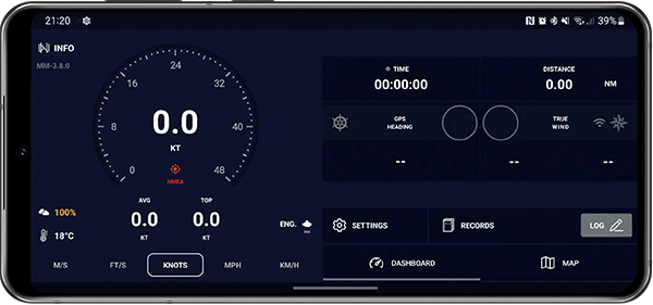
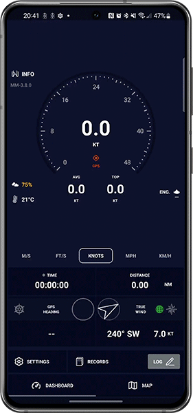
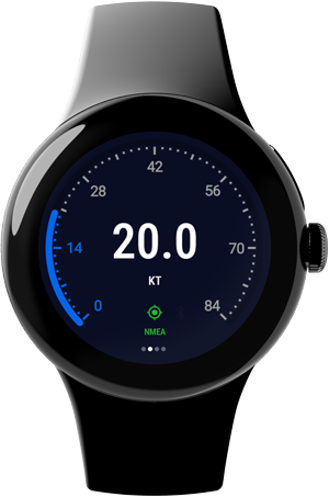
Indicators for your geolocation and wind sources are displayed on the main dashboard. Your geolocation source will be shown under the main speedometer’s status indicator as ‘GPS’ or ‘NMEA’. Your wind source will be indicated in the wind panel with an icon:

Connecting to the NMEA network
The apps support the following connection modes as of version 3.8:
- TCP Client
- TCP Server
- UDP
Connect to your boat’s WiFi network using your device system settings. In the app, choose the TCP or UDP setting that matches your NMEA gateway’s configuration and type in your gateway’s IP address and port number.
⌚️ Separate devices must be configured individually. The watch app in Standalone mode will not synchronise NMEA network info with the paired handheld device. The watch app in Tethering mode will use the phone’s configuration.
Configuring data sources
🛰+💨 GPS and wind
Set your ‘Geolocation, speed, and heading’ source to ‘NMEA 0183’ to use this as your primary source for location data instead of your phone’s internal GPS.
If your ‘Wind’ source is set to ‘Automatic’, it will use NMEA to stream wind data if your ‘Geolocation, speed, and heading’ source setting is ‘NMEA 0183’.
🛰 GPS only
If you’d like to use NMEA only for geolocation and not for wind data, set your ‘Geolocation, speed, and heading’ source to ‘NMEA 0183’ and set your wind source to one of the alternatives.
Alternative options for the wind source are ‘Internet’ to source wind data from your nearest weather station over your data connection, or ‘SailTimer’ to use a SailTimer Wind Instrument over bluetooth.
💨 Wind only
If you’d like to use NMEA only for wind data and not for geolocation, set your ‘Geolocation, speed, and heading’ source to ‘Internal GPS’, and set your ‘Wind’ source to ‘NMEA 0183’.
You can also configure the ‘wind’ source from the main dashboard in the handheld app. Tap on the wind section on the bottom right of the lower panel to switch between available sources.
Smartwatch App
If the Mariner app on your smartwatch is set to ‘tethering mode’, it will use whichever geolocation and wind sources you’ve set up on your phone. Your GPS source will appear on the main speedometer display as ‘HANDHELD’ instead of ‘GPS’, ‘HYBRID, or ‘NMEA’. The wind source will be indicated on either one of the wind displays in the watch app.
Status notifications
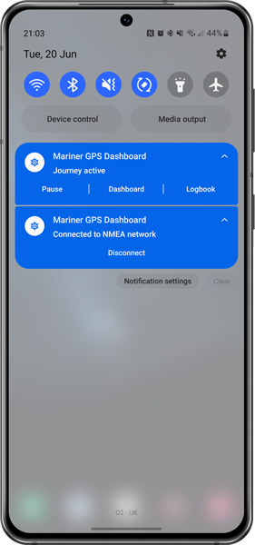
Depending on your combination of geolocation and wind sources, one or two notifications may appear in in your notification panel.
All Android and Wear OS apps are required display such notifications to keep you informed of any ongoing connections at all times. This makes it possible for you to maintain ongoing connections while you use other apps.
You can also stop any active connections without opening the app.
If both geolocation and wind sources are NMEA, a single ongoing notification will appear as long as the app is running.
If your geolocation source is GPS and your wind source is NMEA, a second notification will appear to stream your wind data independently of your GPS connection and journey session.
ℹ️ It is possible to hide the active connection notifications using the Android system settings. However we do not recommend this as it may interfere with the normal functioning of the app.
Recording logbooks with NMEA
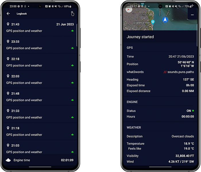
Mariner records your journey and logbook from the location source you have selected. The app automatically records logbook entries between intervals. You can customise how long you want these intervals to be in the main settings menu or logbook settings menu via the ‘LOG’ button on the main dashboard. Learn more about automating your marine logbooks with this guide:
Exporting recorded data
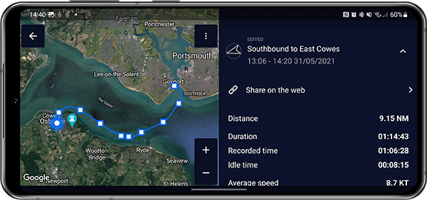
There are a number of ways you can export your recorded journey from the handheld app. Mariner supports several file formats such as GPX, CSV, Plaintext, and more. Learn all about these formats and how to export files with this guide:
A versatile dashboard for all kinds of watercraft
Mariner is designed to utilise the latest mobile and wearable tech to bring better navigational awareness to sailors of all kinds of crafts. While the app can serve as a useful aid to navigation and safety, it is important to remember to keep your focus on your surroundings and prioritise the safety of yourself, your crew, and other vessels at all times.
We’re always working to improve Mariner for Wear OS and Android. We welcome your feedback so we can prioritise what matters to you most in the next release.
Download Mariner GPS Dashboard for marine vessels on Google Play:
Follow us on Instagram, Facebook and LinkedIn.