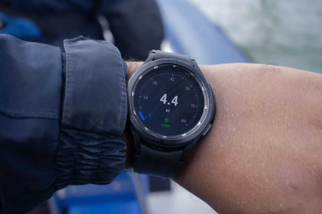
Mariner GPS Dashboard is a versatile GPS dashboard app for sailors of all kinds of marine vessels. Use Mariner’s wearable navigation displays to improve your situational awareness while underway. You can record your journeys and automate data collection for your logbook. This guide details the capabilities of the wearable app and how to get it up and running on your Wear OS smartwatch.
The RAMS series (Road Air Marine Speedometers) is a range of handheld and wearable GPS Dashboard apps tailored specifically to different modes of transport; Velocity for land vehicles and Mariner for marine vessels.
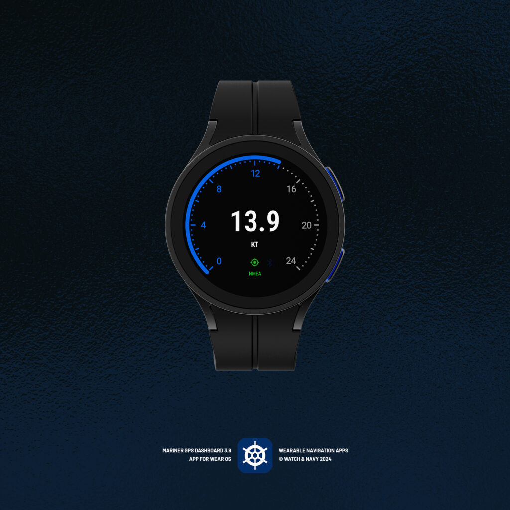
Marine Navigation Display and Speedometer for Wear OS
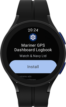
Download and Install
Download Mariner GPS Dashboard from the Play Store on your watch. You can do this from your desktop browser while signed into your Google account, or directly from the Play Store app on your watch.
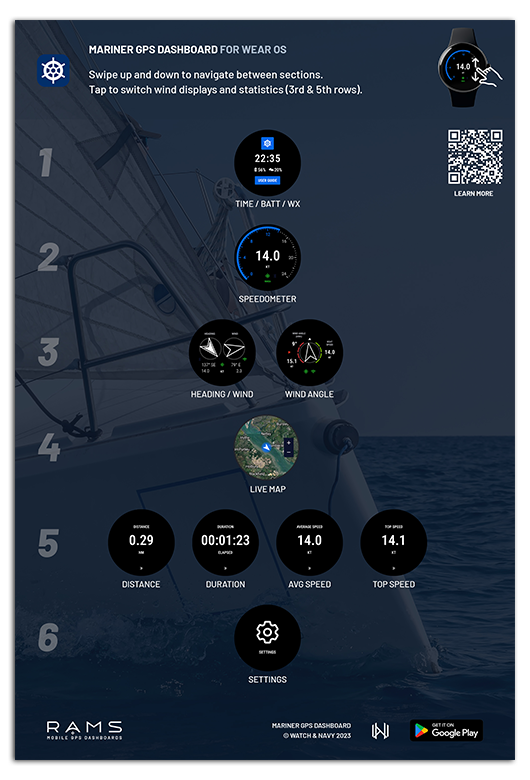
Map of displays / quick reference guide
Mariner for Wear OS is designed for easy switching between data displays, and for each display to be legible at a glance while sailing. Swipe up and down to navigate between each section. Tap ›› on any statistic display (time elapsed, distance, average and top speeds) to cycle between them. Using your watch’s crown or rotating bezel is the fastest way to move between displays.
Refer to this handy Quick Reference Guide to learn where each of the displays are:
Getting started
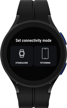
When you start the app for the first time you will be prompted to select your preferred connectivity mode for the app:
1. ⌚️ Standalone mode (use watch GPS independently)
Choose ‘standalone’ mode to use the app on your watch entirely independently of your smartphone. As of Mariner 3.9, you can record a journey on your watch and it will be synchronised with your handheld device when you finish the session.
ℹ️ You can record journeys on your watch as of version 3.9 (February 2024)
2. 📱 Tethering mode (use GPS from paired handheld app)
In tethering mode, your recording session will be synchronised with the app on your paired smartphone. All journey statistics will be mirrored from the phone, and your watch will act as a secondary display.
When you start a journey in tethering mode, your watch will attempt to start the app on your phone and begin recording your journey. On some phones, and depending on your system settings, you may have to start the app manually if the system is in sleep mode. You may need to change your power management settings to allow Mariner to start up in the background.
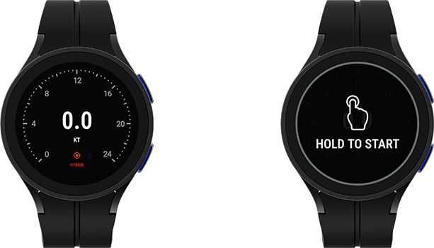
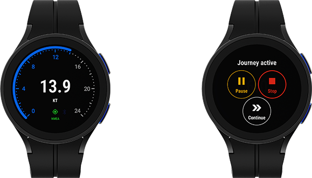
Starting and stopping journeys
To start a journey manually, tap and hold on the screen to start the session. A single tap will prompt you to tap and hold. The ‘tap and hold’ action is a safeguard to prevent you from activating the GPS when you don’t intend to.
While you have an active journey session, tap on the screen for the pause and stop controls; the continue button below will dismiss these controls. If you are in tethering mode, these buttons will not interrupt the journey/recording session on your phone.
Wind displays – speed, direction, and angle
You can select one of three sources for wind data in standalone mode:
- Internet weather provided by OpenWeatherMap
- NMEA 0183 (TCP Client, TCP Server, and UDP modes)
- SailTimer Wind Instruments via your paired handheld device
Your wind source will be indicated in the wind panel with an icon:

The app will use the internet to fetch the weather by default. You can configure your wind source in the settings menu. In tethering mode your wind source will be determined by the settings on your smartphone or tablet.
1. Heading + wind direction mode
Swipe right-to-left on the speedometer display to switch to Heading & Wind mode. Your watch will pick up local weather information from the internet and display it alongside your boat speed and direction. Below the directional arrows you’ll see the heading and wind direction in degrees, and the speed of each underneath.
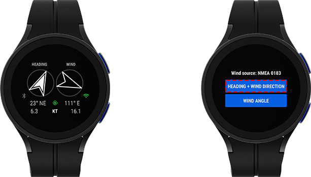
Tap on the Heading & Wind mode display will show the current Weather source. You can choose your weather data source in settings. If you are in GPS tethering mode and you have SailTimer as the wind source on your smartphone, the live wind speed and direction data will be streamed from your phone into the wind section, and a bluetooth signal indicator will appear to the bottom-right of the wind direction arrow.
2. Wind angle mode
📱 GPS Tethering mode only.
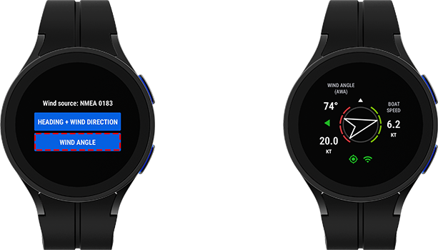
If you are using NMEA 0183 in standalone mode, or a SailTimer Wind Instrument connected to your smartphone in tethering mode, you can stream live wind angle data onto your watch. Tap on the Heading & Wind mode screen to switch to wind angle mode.
Check out the following article to learn about the SailTimer device and how to get set up:
GPS and wind data sources
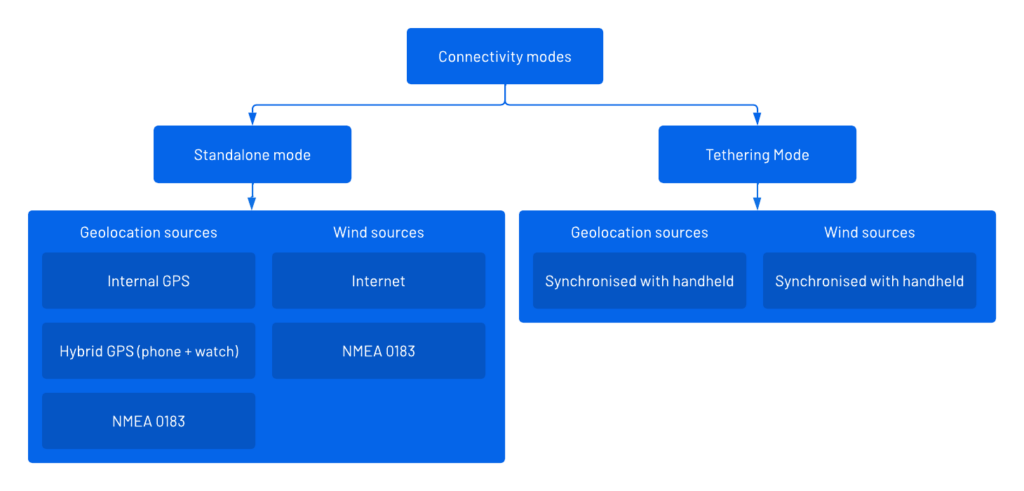
In standalone mode you have three options for your GPS data source: ‘Internal GPS’, ‘Hybrid GPS’, and NMEA 0183.
‘Hybrid mode’ is the default setting in standalone mode that works by combining GPS signals from both your watch and phone or tablet for more accurate and timely GPS signals.
‘Internal GPS’ uses only the GPS hardware built into your smartwatch.
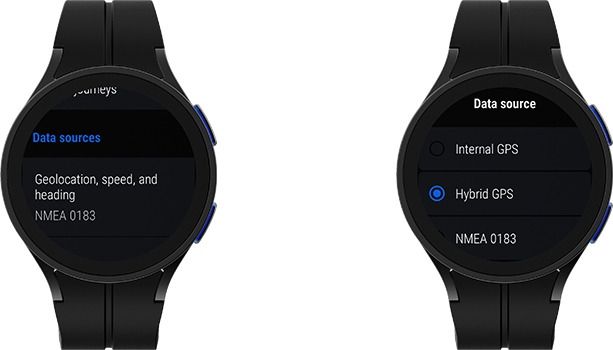
💡 You don’t have to have the app installed on your handheld device to use its signals in hybrid GPS mode.
You can choose your GPS and wind data sources independently of each other. You can connect to your boat’s NMEA 0183 network by setting either one of your data sources in the settings menu.
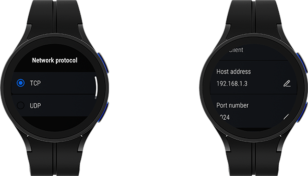
Connecting to an NMEA Network
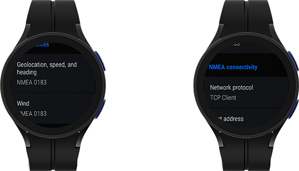
Mariner 3.8+ supports the following NMEA 0183 network protocols:
- TCP Client
- TCP Server
- UDP
Ensure that your device is connected to the NMEA network, then enter the address and port number of your NMEA gateway into the app.
Learn more about the NMEA 0183 in Mariner 3.8+
Map Display
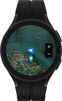
Mariner features detailed satellite maps so you can easily stay aware of your surroundings from anywhere on board. Use the + and – buttons to adjust the zoom level to your preference. You can toggle between satellite and standard map views in the settings menu to suit your preference.
Signal indicators
The following two indicators will appear on the speedometer depending on the GPS source that you set:
GPS Connectivity
The three-colour blinking signal indicator is used throughout the app so that you’ll be able to quickly gauge your signal strength at any time.
Bluetooth connectivity
📱 GPS Tethering mode only.

In tethering mode your bluetooth connection status will be indicated on the speedometer view with one of two colours. This indicator will appear amber while the watch waits for the first signal from the smartphone app, or if it loses connectivity during your journey session.
Be ready for all kinds of adventure
Mariner is designed to utilise the latest mobile and wearable tech to bring better navigational awareness to sailors of all kinds of crafts. While the app can serve as a useful aid to navigation and safety, it is important to remember to keep your focus on your surroundings and prioritise the safety of yourself, your crew, and other vessels at all times.
Check out the handheld version of Mariner for more useful capabilities such as logbook automation, travel time estimation, and journey data exports.
We’re always working to improve Mariner for Wear OS and Android. We welcome your feedback so we can prioritise what matters to you most in the next release.
Download Mariner GPS Dashboard for marine vessels on Google Play:
Follow us on Instagram, Facebook and LinkedIn.