With the RAMS GPS Dashboard apps you can create detailed recordings of your outdoor adventures and save them into various different file formats for viewing on all kinds of devices and in other apps. This guide lists and explains the 4 formats currently supported as of versions 3.4+ and how you can use them to share and analyse GPS data.
RAMS (Road Air Marine Speedometers) is a range of mobile and wearable GPS Dashboards tailored specifically to different modes of transport; Velocity for land vehicles and Mariner for marine vessels.
File types
1. GPS Exchange Format (.gpx)
GPX is a standardised file format used by many GPS devices, apps, and websites across all platforms for reading and writing route data. It’s based on XML (Extensible Markup Language) and has become widely used since its launch in 2002.
For those already familiar with the format, GPX files generated by RAMS apps include the entire track in a single segment object. Each track point <trkpt/> includes a timestamp, GPS coordinates, elevation (if available), and the speed in meters per second. Saved locations and marine logbook entries are added as waypoints <wpt/>.
Example
<?xml version="1.0" encoding="UTF-8"?>
<gpx creator="Mariner GPS Dashboard https://watchandnavy.com/rams-mariner">
    <trk name="Southbound to Isle of Wight">
        <trkseg name="Part 1">
            <trkpt lat="50.79080698" lon="-1.11642122" ele="0.0" time="2021-04-30T12:21:38.926Z" speed="6.423135"/>
            <trkpt lat="50.79084034" lon="-1.11637261" ele="0.0" time="2021-04-30T12:21:39.961Z" speed="6.423135"/>
            <trkpt lat="50.79087371" lon="-1.11632399" ele="0.0" time="2021-04-30T12:21:41.016Z" speed="5.052086"/>
            <trkpt lat="50.79090707" lon="-1.11627538" ele="0.0" time="2021-04-30T12:21:42.068Z" speed="5.0520864"/>
            <trkpt lat="50.79094043" lon="-1.11622676" ele="0.0" time="2021-04-30T12:21:43.145Z" speed="5.0520864"/>
	    </trkseg>
	</trk>
	<wpt lat="50.75820577" lon="-1.29164158">
		<name>30 Apr 2021 14:21:41</name>
		<desc>Elapsed time: 1h 00
		      Elapsed distance: 10.0 NM
		      Course steered: 185° S
		      Weather: Few clouds
		      Temperature: 9.5 °C
		      Feels like: 9.5 °C
		      Visibility: 5 NM
		      Wind: 0.9 Kt / 137° SE
		      Cloudiness: 16%
		      Humidity: 66%
		      Atmospheric pressure: 1013 hPa
		</desc>
	</wpt>
</gpx>
2. JavaScript Object Notation (.json)
JSON is the most commonly used format for transferring data between modern mobile and web applications. Unlike GPX, this format does not have a standardised schema for GPS data, so a RAMS-exported JSON file will not be readable by other navigation software and devices. We’ve included this option for those who may prefer to analyse their raw recorded data in the more lightweight file format.
Compared to XML-based GPX, JSON files are more human-readable and considerably smaller in size since there’s no added bulk from repeated tags such as <trk/> and <wpt/>. They can be viewed with JSON-formatting websites (such as this one), web browser extensions, and many mobile and desktop applications.
In a RAMS JSON export file, your speed, distance and temperature units are readily converted to your preferred units, all of which can be customised in the settings menu. The names of your preferred units are also included in the statistics block at the top of the document.
Example
{
  "name": "Southbound to Isle of Wight",
  "start_address": "Seaward Tower, Trinity Green, Gosport PO12 1HG, UK",
  "end_address": "50 Britannia Way, East Cowes PO32 6DQ, UK",
  "start_timezone": "Europe/London",
  "start_time": "13:21:38",
  "start_date": "30 Apr 2021",
  "end_timezone": "Europe/London",
  "end_time": "14:24:31",
  "end_date": "30 Apr 2021",
  "total_duration": "01:02:52",
  "recorded_time": "01:02:52",
  "idle_time": "00:00:00",
  "top_speed": "12.5 Kt",
  "average_speed": "10.5 Kt",
  "distance": "10.5 NM",
  "device": "HUAWEI CLT-L09",
  "speed_unit": "Knots",
  "distance_unit": "Nautical Miles",
  "temperature_unit": "Celsius",
  "creator": "com.watchandnavy.rams.mariner",
  "track": [
    {
      "time": "13:21:38",
      "speed": "12.5 Kt",
      "latitude": 50.79080698,
      "longitude": -1.11642122,
      "accuracy_meters": "5 M"
    },
    {
      "time": "13:21:39",
      "speed": "12.5 Kt",
      "latitude": 50.79084034,
      "longitude": -1.11637261,
      "accuracy_meters": "5 M"
    }
  ],
  "logbook": [
    {
      "local_timezone": "Europe/London",
      "time": "13:21:40",
      "date": "30 Apr 2021",
      "description": "Journey started",
      "elapsed_distance": "0.0 NM",
      "elapsed_time": "00:00:01",
      "heading_degrees": "43°",
      "latitude": 50.79084034,
      "longitude": -1.11637261,
      "accuracy_meters": "5 M",
      "weather_description": "Few clouds",
      "weather_temperature": "9.5 °C",
      "weather_temperature_feels_like": "9.5 °C",
      "weather_wind_speed": "0.9 Kt",
      "weather_wind_direction": "137°",
      "weather_cloudiness": "16%",
      "weather_visibility": "5.4 NM",
      "weather_humidity": "66%",
      "weather_atmospheric_pressure": "1013 hPa",
      "engine_status": "ON",
      "engine_time_elapsed": "00:00:00"
    },
    {
      "local_timezone": "Europe/London",
      "time": "13:41:40",
      "date": "30 Apr 2021",
      "elapsed_distance": "3.3 NM",
      "elapsed_time": "00:20:02",
      "heading_degrees": "247°",
      "latitude": 50.75243467,
      "longitude": -1.14607588,
      "accuracy_meters": "5 M",
      "weather_description": "Few clouds",
      "weather_temperature": "9.5 °C",
      "weather_temperature_feels_like": "9.5 °C",
      "weather_wind_speed": "0.9 Kt",
      "weather_wind_direction": "137°",
      "weather_cloudiness": "16%",
      "weather_visibility": "5.4 NM",
      "weather_humidity": "66%",
      "weather_atmospheric_pressure": "1013 hPa",
      "engine_status": "ON",
      "engine_time_elapsed": "00:20:00"
     }
  ]
}
With all RAMS apps you can export entire journey data including overall statistics, each individual GPS reading, saved locations and marine logbook entries. With Mariner you can export your full-detailed journey or just your logbook data.
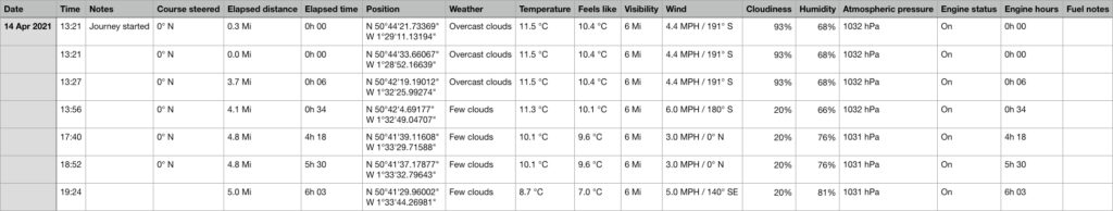
3. Comma-separated values (.csv) for Marine logbooks
Mariner GPS Dashboard exports logbook data into the CSV format readable by any well-known spreadsheet app such as Microsoft Excel, Apple Numbers or Google Sheets.
Example
4. Plaintext (.txt) for Marine Logbooks
Plaintext is the ideal format for blogging and presenting. It’s ready to be pasted straight on to a blog, or styled and converted into a PDF or word document.
Example
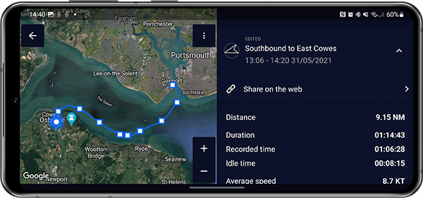
Southbound to East Cowes
13:06 - 14:20 31/05/2021

Distance: 8.96 NM
Duration: 01:14:43
Recorded time: 01:06:07
Idle time: 00:08:36

Average speed: 9 Kt
Top speed: 9 Kt

Device: HUAWEI CLT-L09
Recorded with Mariner GPS Dashboard

------------------------------
31 May 2021
------------------------------
Entry at 13:06

Position: 1°6'58" W, 50°47'27" N
Heading: 43° NE
Elapsed time: 0h 00
Elapsed distance: 0 NM

Engine: On
Elapsed time: 0h 00

Weather: Few clouds
Temperature: 23.1 °C (Feels like 22.8 °C)
Wind: 8.57 Kt / 99° E
Cloud coverage: 20%
Visibility: 5 NM
Humidity: 55%
Pressure: 1022 hPa

Notes: Journey started

------------------------------
Entry at 13:16

Position: 1°6'35" W, 50°46'26" N
Heading: 223° SW
Elapsed time: 0h 10
Elapsed distance: 1.38 NM

Engine: On
Elapsed time: 0h 10

Weather: Few clouds
Temperature: 23.1 °C (Feels like 22.8 °C)
Wind: 8.57 Kt / 99° E
Cloud coverage: 20%
Visibility: 5 NM
Humidity: 55%
Pressure: 1022 hPa
Learn more:
5. RAMS Compressed Backup Format (.rams3backup)
This format is solely for backing up your journey data onto your device file system, and can only be read by one of the RAMS apps. You can back up either your entire journey history or individual journeys in this format. It’s based on compressed JSON and is not readily encrypted.
The RAMS Cloud offers a secure and convenient way to keep your data backed up and synchronised between all of your logged-in devices.
🔗 Learn about our cloud security practices.
Share on the web
As of RAMS 3.7 you can also create a URL link to your journeys for viewing in a web browser. Learn about the capabilities of the Cloud Journey Viewer and how to create web links here:
How to start recording
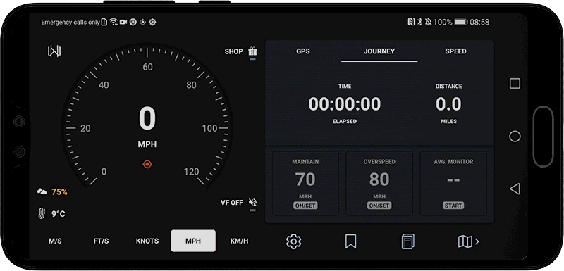
Simply tap on the speedometer, choose your vehicle type and swipe right to start your journey; tap on it again to pause or stop. You can also control the journey recorder from the sticky notification while recording in the background.
We have many more new features in the pipeline to make the RAMS GPS Dashboards ever more capable in a wider range of use cases. Your suggestions are always welcome to make future updates even better.
Download Mariner GPS Dashboard for marine vessels on Google Play:
Download Velocity GPS Dashboard for road vehicles on Google Play:
Follow us on Instagram, Facebook and LinkedIn.