It’s hard to imagine modern life without GPS. When it comes to mapping a new route or monitoring a cargo delivery, the Global Positioning System underpins everything from transport and telecommunications to weather forecasting and emergency services. And yet, few people understand how GPS actually works or why, at times, it doesn’t.
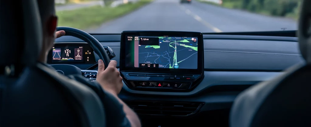
We’ve come to expect our phones and devices to know where we are within seconds, accurate to within a few metres. But that accuracy isn’t consistent. Urban canyons, tunnels, weather conditions, and even the quality of your device all affect how precise that location fix will be. Some days, your GPS can track you step-by-step down a footpath. Other days, it may drop your location into the middle of a field you’ve never stepped foot in.
This article breaks down the inner workings of GPS. We’ll explore the technology behind it, the different systems in play, what causes accuracy to vary, and what the future holds. Along the way, we’ll highlight key use cases and explain why not all GPS is created equal.
Understanding the Basics: What GPS Really Is
GPS is something we use almost instinctively to get directions, track parcels, or monitor exercise. But behind that familiar blue dot on a map is a vast system of satellites, signals, and calculations. Before we get into how GPS works in detail, it helps to understand what the system actually is and how it fits into the broader satellite navigation landscape.
GNSS vs GPS
When people say “GPS”, they’re often referring to any satellite-based positioning system. But GPS is just one part of a broader category called Global Navigation Satellite Systems (GNSS). The term GNSS includes several systems operated by different countries:
- GPS (🇺🇸 United States)
- GLONASS (🇷🇺 Russia)
- Galileo (🇪🇺 European Union)
- BeiDou (🇨🇳 China)
Most modern smartphones and navigation devices are designed to use multiple GNSS constellations simultaneously. This multi-system support increases the number of visible satellites and, in turn, improves accuracy, especially in environments where the signal might be obstructed.
What Is GPS?
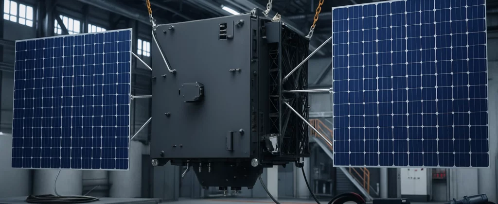
GPS itself is a satellite-based radio navigation system developed by the United States Department of Defence. Though originally intended for military use, it was made available to civilians in the 1980s and has since become the global default.
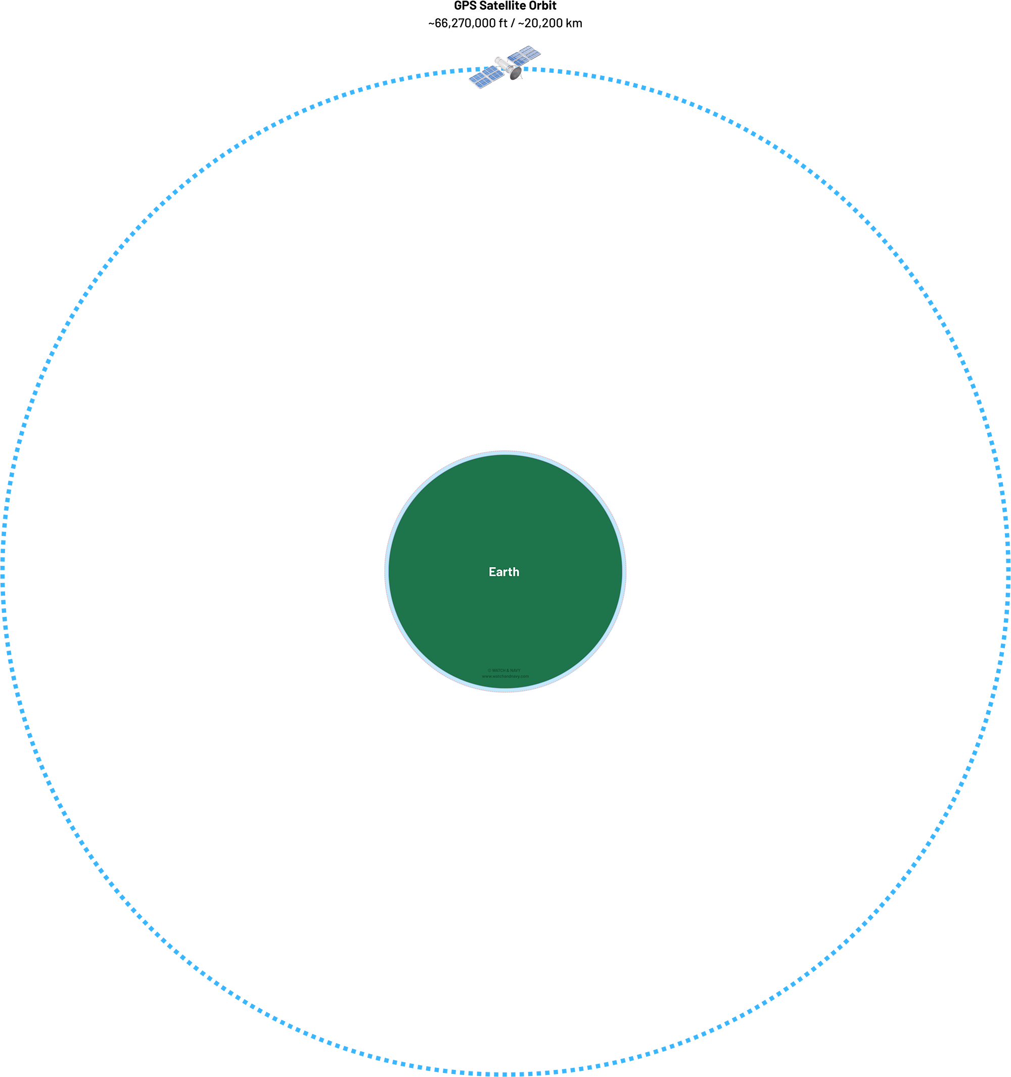
The system consists of at least 24 active satellites orbiting approximately 20,000 kilometres above Earth. These satellites are arranged so that, from anywhere on the planet, at least four are visible at any given time.
Each satellite transmits a continuous signal that includes its location and the exact time the message was sent. These signals travel at the speed of light and are picked up by GPS receivers, the chips embedded in your phone, watch, car, or drone.
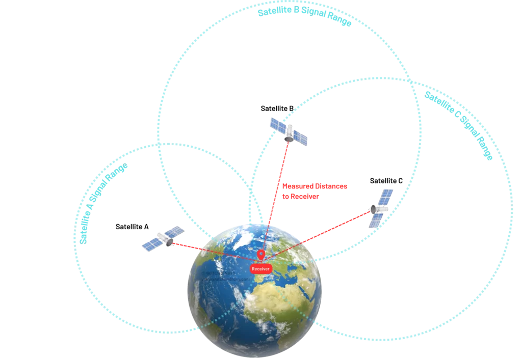
Trilateration: How Position is Calculated
To understand how GPS determines your location, we need to look at the principle of trilateration, a mathematical process that turns timing data into geographical position. This is where things start to get technical, but it’s also where the real ingenuity of the system becomes clear.
The receiver determines its distance from multiple satellites by calculating how long each signal took to arrive. Since the speed of light is constant, the time delay equals distance. When the receiver has timing information from at least four satellites, it can solve a set of equations to determine:
- Latitude
- Longitude
- Altitude
- Time
The more satellites a receiver can access, the better its positional accuracy. It’s also why GPS tends to be less accurate in built-up areas where fewer satellites might be visible.
How GPS Signals Work

Knowing that GPS relies on signals from orbiting satellites is one thing, understanding how those signals are used to calculate a precise location is another. Behind the scenes, GPS depends on split-second timing, high-frequency radio transmission, and a great deal of mathematical processing.
Each step in the chain, from signal generation in space to the moment your phone drops a pin on a map, plays a role in how accurate, fast, or flawed that final location might be.
Atomic Clocks in Orbit
One of the most impressive elements of GPS technology is the use of atomic clocks. Every satellite in the GPS constellation carries multiple atomic clocks that keep time with extraordinary precision, accurate to within a few nanoseconds.
Why does timing matter so much? Because the receiver relies on the difference in arrival times of each signal to calculate distance. A one-microsecond error would translate to a positional error of about 300 metres. When working with locations accurate to within a few metres, or centimetres in some systems, even the tiniest drift becomes critical. That’s why satellite timing has to be exact, and why your GPS chip constantly adjusts and corrects its calculations using the highly reliable time data it receives from orbit.
Without these atomic time references, GPS simply wouldn’t work.
 An atomic clock keeps time by measuring the exact frequency of atom vibrations — usually caesium or rubidium. These atoms oscillate at a consistent rate, acting like a perfect metronome. GPS satellites use atomic clocks to keep time accurate to within nanoseconds, which is crucial for pinpointing your location.
Breaking Down the GPS Signal
Each GPS satellite sends out a signal via L-band radio waves, which are well suited for long-distance travel and can pass through the atmosphere with minimal disruption. These signals are broadcast continually and picked up by GPS receivers on Earth, including those in smartphones, vehicles, and industrial equipment.
The signal carries several key pieces of information:
- Timestamp – The exact time the message left the satellite
- Orbital Data (Ephemeris) – The satellite’s current position and health
- Almanac Data – General data about the location and status of other satellites in the constellation
And more…
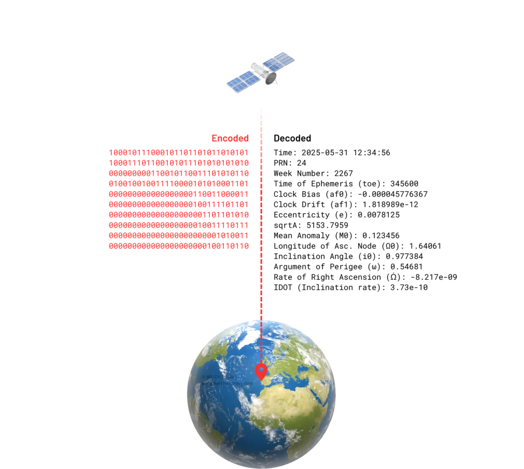
Using this data, a GPS receiver knows not only where a given satellite was at the time of transmission, but also where others should be. This is vital for the receiver to identify which satellites to lock on to and to estimate an initial fix quickly.
Most consumer devices use the L1 frequency (1.57542 GHz). Newer or more advanced GPS chips also receive signals on L2 and L5 frequencies. These allow for greater precision and better error correction, especially when dealing with signal distortion caused by the atmosphere.
From Signal to Position
Once the GPS receiver collects signals from multiple satellites, it starts calculating how long each signal took to reach it. By comparing the timestamp in the signal with the device’s own internal clock, it can estimate how far it is from each satellite.
These distance calculations form the basis for trilateration, where your position is derived based on the intersection of multiple spherical ranges around satellites in space. This data is then matched with mapping coordinates to provide an exact location, usually in latitude, longitude, altitude, and time.
The process doesn’t stop once a fix is found. Your GPS receiver continues to monitor satellite signals, adjusting for small changes in orbit or clock drift, and re-running calculations in real time. Most smartphones do this several times per second, maintaining a live lock on your changing location.
To help refine the estimate further, particularly in areas with limited sky visibility, many devices combine GPS data with input from other onboard sensors. Accelerometers, gyroscopes, and barometers can all help “fill in the gaps” when a signal drops, such as during a tunnel crossing or while moving through dense city blocks.
Types of GPS and Use Cases

Not all GPS is created equal. While the general principle of satellite-based location remains the same, there are several types of GPS technologies in use today, each offering different levels of accuracy, speed, and reliability. These variations depend on factors such as signal frequency, whether additional data sources are used, and the intended application.
From smartphones and car navigation systems to surveying equipment and autonomous machinery, the type of GPS in use can have a significant impact on performance.
◆ Standard GPS (L1 Only)
Most consumer devices, including smartphones, smartwatches, fitness trackers, and in-car sat nav systems, use standard single-frequency GPS. This system operates on the L1 band, broadcasting at 1.57542 GHz, and provides positional accuracy typically within 5 to 10 metres in good conditions.
For everyday navigation, this is usually sufficient. However, single-frequency GPS can struggle in dense urban environments or anywhere that signal reflections, obstructions, or atmospheric conditions interfere with the signal.
Despite these limitations, L1-only GPS is cost-effective, requires less processing power, and works well enough for most general-purpose applications.
◆ Dual-Frequency GPS (L1 + L5 or L2)
Dual-frequency GPS receivers can access two separate signals from each satellite, often L1 and L5 (or L2 in older military systems). By comparing the differences between these frequencies, the receiver can correct for many atmospheric distortions that affect accuracy.
Some newer smartphones and specialised devices include dual-frequency GPS capabilities. This allows for higher precision, often accurate within 30 centimetres, and much faster position fixes. It’s particularly beneficial in challenging environments, such as urban areas with tall buildings or deep canyons, where standard GPS may struggle.
This type of GPS is commonly used in aviation, geolocation-critical applications like augmented reality, and in some high-end consumer tech aimed at professional or technical users.
◆ Assisted GPS (A-GPS)
A-GPS combines satellite signals with additional location data from mobile networks and internet services. It is most commonly used in smartphones to speed up the time it takes to get a location fix, particularly in areas with poor sky visibility.
Instead of waiting for satellite signals alone, A-GPS pulls data from nearby cell towers, Wi-Fi networks, and cloud-based satellite predictions. This results in much faster and more reliable location detection, especially when you are indoors or in a densely built-up area.
A-GPS is not a separate GPS system, but rather an enhancement that relies on external infrastructure to improve performance.
◆ Differential GPS (DGPS)
Differential GPS is used in situations where higher accuracy is required than standard GPS can provide. It works by using a network of fixed, ground-based reference stations that compare their known locations with satellite data. The system then calculates correction signals and sends these to DGPS-enabled receivers.
This method can reduce positioning errors to less than one metre. DGPS is widely used in maritime navigation, agricultural equipment, surveying, and coastal infrastructure, where precision is vital but real-time performance demands are moderate.
Some regions offer DGPS as a public service, while in other areas, private networks deliver the correction data.
◆ Real-Time Kinematic (RTK) GPS
At the highest end of precision is RTK GPS, a system that uses carrier-phase tracking and real-time corrections to achieve location accuracy within a few centimetres or even millimetres.
RTK relies on a fixed base station and one or more mobile receivers. The base station continuously receives satellite data and sends correction signals to the moving units via radio or mobile networks.
RTK is commonly used in land surveying, precision farming, construction, drone navigation, and autonomous vehicles. The accuracy comes at the cost of complexity, as it requires stable communication between the base and the rover, as well as line-of-sight to multiple satellites.
Choosing the Right GPS System
The best GPS setup depends on what you need it for. For casual navigation, single-frequency GPS is more than adequate. For detailed mapping, fieldwork, or autonomous systems, dual-frequency or RTK solutions offer the precision required to operate within narrow margins.
| GPS Type | Frequency Bands | Accuracy Range | Latency | Typical Use Cases | Hardware Cost |
| Standard GPS | L1 | ~5–10 meters | Low | Smartphones, basic navigation, fitness trackers | £ |
| Dual-Frequency GPS | L1 + L5 (or L2) | ~1–3 meters | Low | Aviation, surveying, flagship smartphones | ££–£££ |
| A-GPS | L1 + Cellular/Wi-Fi assist | ~3–10 meters | Very Low | Phones in urban areas, emergency services | £ (uses phone SIM) |
| DGPS | L1 (with ground corrections) | ~0.5–3 meters | Medium | Maritime, agriculture, vehicle tracking | ££ |
| RTK GPS | L1 + L2/L5 (with corrections) | ~1–2 centimeters | High (requires setup) | Precision agriculture, construction, drone mapping | £££ |
Why Accuracy Varies
Even with a clear understanding of how GPS works and which system you’re using, location accuracy can still vary significantly. You might get pinpoint tracking on a coastal trail one day, then find yourself ten metres off course in a city centre the next.
These differences are not random. They stem from a combination of physical obstructions, environmental conditions, technical limitations, and satellite geometry.
Environmental Interference
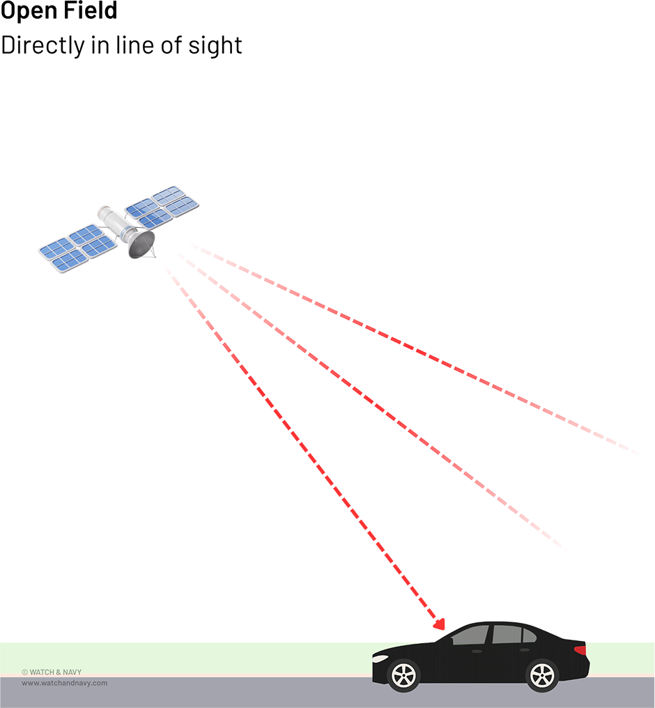
The most immediate and visible reason for reduced accuracy is physical obstruction. GPS relies on a direct line of sight to multiple satellites. When that line is broken by buildings, trees, tunnels or even your own body, signal strength drops, and accuracy suffers.
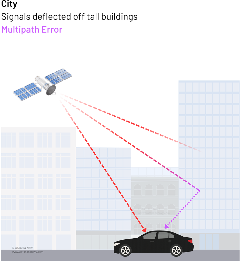
In cities, this is known as the urban canyon effect. Tall buildings reflect GPS signals, causing them to bounce off walls before reaching your device. This results in multipath error, where the receiver calculates position based on a delayed signal that has taken a longer, indirect route. The more reflections involved, the worse the accuracy.
Forests and mountainous areas can create similar issues. While they may not reflect signals like concrete does, dense foliage and topography still weaken or block reception. In these environments, even a few metres of deviation can cause practical problems for navigation.
Atmospheric Conditions
While space and hardware often take the blame for poor positioning, the Earth’s atmosphere also plays a role. GPS signals must pass through the ionosphere and troposphere before reaching your device. Both layers can bend or delay the signal slightly, depending on weather and solar activity.
GPS Satellite Orbit
Atmospheric Layers
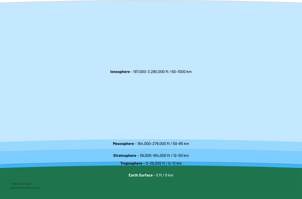
In the ionosphere, charged particles can slow or distort the signal, especially during periods of high solar radiation or geomagnetic storms. This can lead to small but measurable errors in timing.
The troposphere, which contains water vapour and weather systems, introduces additional delays. Humidity, temperature, and air pressure all affect how radio waves travel. While these distortions are typically small, they can accumulate, especially for long-range signals.
Higher-end GPS receivers, particularly those using dual-frequency signals, are better equipped to compensate for atmospheric effects by comparing how different frequencies behave in the same conditions.
Device and Hardware Limitations
The quality of the GPS receiver itself plays a major role in how accurately it interprets signals. Antennas, chipsets, and signal processing algorithms all vary between devices.
In smartphones, space is limited. GPS antennas must be small and share room with dozens of other components. They are also subject to interference from other radios (Wi-Fi, Bluetooth, 4G/5G). As a result, even under ideal conditions, a phone’s GPS signal might be slightly degraded compared to a dedicated outdoor GPS device.
Some manufacturers use sensor fusion to improve results, combining data from GPS with inertial sensors, magnetometers, and sometimes even barometric pressure. This can help smooth out tracking data when GPS is unstable, but it is still reliant on good signal to maintain accuracy over time.
Satellite Geometry (GDOP)
GPS accuracy depends not only on how many satellites you can see, but also where they are in the sky. If satellites are clustered in one area of the sky or are low on the horizon, the positional fix they provide will be less reliable.
This concept is measured by something called Geometric Dilution of Precision (GDOP). A low GDOP value means satellites are well-spaced across the sky, leading to a more accurate and stable position. High GDOP, where satellites are too close together or at poor angles, increases uncertainty in the calculated location.
GDOP can change from minute to minute depending on satellite movement and your location. Many GPS apps offer GDOP monitoring, which can help explain why accuracy might drop temporarily, even in otherwise open environments.
Improving Accuracy: What You Can Control

Although many factors affecting GPS accuracy are beyond your control, there are practical steps you can take to improve the quality of your location data. Whether you’re using a smartphone, a GPS watch, or a handheld navigation device, small adjustments in behaviour or settings can make a noticeable difference.
Stay in Open Spaces When Possible
The simplest way to improve GPS accuracy is to ensure a clear view of the sky. Open environments such as parks, hills, or wide roads allow your device to connect with more satellites simultaneously. Avoid standing near tall buildings, walls, or dense trees while waiting for a position fix.
If you’re indoors, move closer to a window or step outside briefly to help your device get an initial lock. Once it has a stable fix, it can often hold the signal for a while, even with some obstruction.
Be Patient With First Lock
When turning on GPS after a period of inactivity, your device may take longer to acquire satellite signals. This is particularly true if you’ve travelled a long distance since last using it. Giving your device 30 to 60 seconds in a stationary, open space can significantly improve the quality of the initial lock.
Some GPS apps will display satellite strength and lock status in real time. Using these can help confirm when your device is ready for accurate tracking.
Use GPS Status Apps or Tools
There are several apps that allow you to monitor satellite count, signal strength, and positioning accuracy directly. Tools such as GPS Status & Toolbox (Android) or GPSTest offer live data on satellite connections, including which GNSS systems are being used and how strong their signals are.
These tools can also reset or speed up GPS lock by clearing outdated satellite data, which is useful if you’re encountering frequent delays or errors.
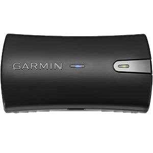
Consider External Antennas or Receivers
For specialist use cases such as surveying, marine navigation, or drone piloting, an external GPS module may offer better performance than your built-in device. These units often include high-gain antennas, support for dual- or multi-frequency tracking, and access to correction services like RTK or SBAS.
Many connect via Bluetooth and are compatible with standard location-based apps, offering a significant upgrade in accuracy for those who need it.
Boost your mobile GPS with this high-accuracy receiver. Combines GPS & GLONASS for faster, more precise location data—updating 10× per second via Bluetooth to your phone or tablet.
The Future of GPS and GNSS
GPS technology is still evolving. New satellites, enhanced signals, and improvements in receiver design are all contributing to greater accuracy, resilience, and accessibility. As GNSS systems around the world expand and mature, we’re seeing the emergence of a new generation of location technology, one that goes far beyond navigation alone. Let’s explore some of the developments shaping the future of satellite positioning:
Next-Generation Signals
The launch of GPS III satellites is gradually improving performance for users around the world. These newer satellites offer stronger, more resilient signals, improved atomic clocks, and additional frequencies such as L5, which provides a dedicated civilian safety-of-life signal.
Other GNSS networks are also upgrading. Galileo, the EU system, is rolling out high-accuracy services with centimetre-level precision, while China’s BeiDou continues to add capabilities including two-way messaging and regional enhancements.
As more satellites become operational and support for additional frequencies becomes standard in devices, signal quality and accuracy will continue to improve.
Multi-Constellation Support
Future devices will increasingly take advantage of multi-constellation capabilities. Rather than relying on GPS alone, newer receivers draw data from several GNSS networks simultaneously, creating more robust and accurate location estimates.
This trend is particularly important in urban and forested environments, where more visible satellites help compensate for signal loss or distortion.
Combined with improved satellite distribution across the globe, multi-constellation tracking will make positioning more stable and consistent, especially in difficult conditions.
Integration with 5G, AI, and Sensors
Location data is now being enhanced with even more data sources as new technologies become available and CPU hardware increases its capabilities. Smartphones and autonomous systems are now combining GPS with 5G positioning, inertial sensors, barometers, and visual data to create a richer picture of the surrounding environment.
This approach, often called sensor fusion, uses artificial intelligence to blend multiple inputs and refine location estimates, even when GPS alone is weak or inaccurate. For indoor use, some technologies are experimenting with Ultra-Wideband (UWB) and Wi-Fi RTT, which offer room-level precision within buildings.
The result is a more seamless navigation experience, not just outdoors, but throughout indoor, underground, or obstructed areas where satellite signals traditionally struggle.
Mobile Apps for Transport and Navigation
As GPS technology continues to evolve, so do our capabilities. At Watch & Navy, we’re committed to harnessing the latest in mobile and wearable innovation to keep improving our apps for transport and navigation. We invite you to explore the range below, and we welcome your feedback on how we can make your experience even better.